tz_china, an efele.net/tz map
A shapefile of the TZ timezones of China
Last data update: November 10, 2009
Last page update: March 26, 2016
TZ version: 2016d
The tz_china shapefile (zip, sha1) captures the TZ timezones of China.
All the geometries are the result of simple operations on China Administrative Regions GIS Data: 1:1M, County Level, 1990, created by Liu Chuang, Yao Xurong, William Laverly et al., published and disseminated by CIESIN, 1996.
The assignment of TZ timezones is based on the description of the zones in 2009r, as well as messages exchanged on the tz mailing list in June-July 2006 (and in particular, the map sent by Jesper Nørgaard Welen on July 14). The description and the discussion explicitly mention the part of Guangdong which is surprisingly in the Asia/Urumqi timezone, and the map accurately reflects the description and discussion.
Snapshot of the shapefile
This is a snapshot of the shapefile, with province boundaries:
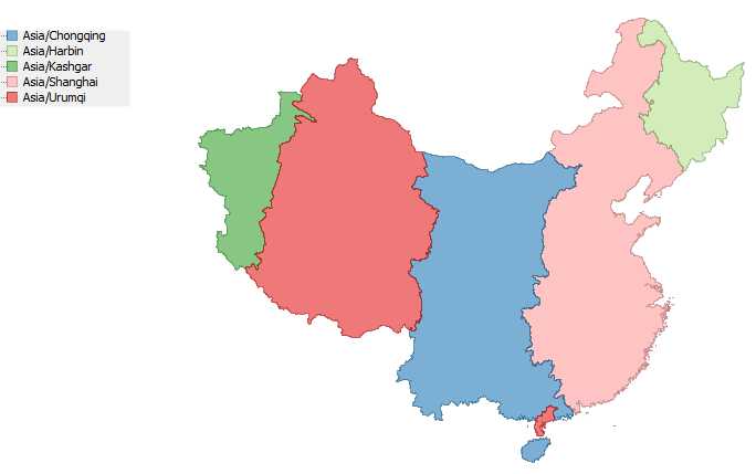
Logical description of the zones
This is a concise description of the zones, using the counties as they existed on December 30, 1990. The names are those in the China Dimensions data.
Asia/Kashgar:
- west part of Xinjiang, limited by and including: Bole, Yining, Nileke, Gongliu, Tekesi, Baicheng, Xinhe, Akesu, Cele, Yutian
- west part of Xizang, limited by and including: Ritu, Geji, Pulan
Asia/Urumqi:
- east part of Xinjiang, limited by and including: Tuoli, Jinghe, Wuso, Hejing, Xinyuan, Kuche, Shaya, Minfeng
- east part of Xizang, limited by and including: Gaize, Longge`er, Zhongba
- west part of Gansu: Subei Mengguzu, Anxi, Dunhuang, Akesai
- west part of Qinghai, limited by and including: Tianjun, Wulan, Dulan, Maduo, Chenduo, Yushu
- west part of Guangdong, limited by and including: Xinyi, Gaozhou, Dianbai
Asia/Chongqing:
- west part of Neimenggu, limited by and including: Siziwang, Chaha`er-Youyihou, Shangdu, Huade, Xinghe
- east part of Gansu, limited by and including: Yumen, Su'nan Yuguzu
- east part of Qinghai, limited by and including: Qilian, Gangcha, Gonghe, Xinghai, Maqin, Dari
- central part of Guangdong: Deqing, Yu`nan, Luoding, Yunfu, Xinxing, Yangchun, Kaiping, Enping, Yangjiang, Taishan, Yangxi
- Ningxiahuizu, Shaanxi, Sichuan, Yunnan, Guizhou, Guangxizhuangzu, Hainan
Asia/Harbin:
- Heilongjiang, less Mohe
- Jilin
Asia/Shanghai:
- east part of Neimenggu, limited by and including: Sunite-You, Xianghuang
- Guandong: east part, limited by and including: Fengkai, Huaiji, Guangning, Gaoyao, Heshan, Xinhui, Doumen, Zhuhai
- Mohe county of Heilongjiang
- Hebei, Liaoning, Beihing, Shanxi, Hebei, Tianjin, Henan, Shandong, Anhui, Jiangsu, Hunan
Construction of the shapefile
The ingredients (zip, sha1) contains a script to build the map from the source as well as cd2tz.csv which lists all the counties, with their name, code, province name, and TZ id.
The starting map is the tbd90 layer of the China Dimensions data collection. (Note that the pbd90 layer is not just a dissolution of the tbd90 layer.)
The source data is converted to a shapefile using the ESRI import71 utility, and reprojected from the original projection/datum to WGS 84 using ogr2ogr.
The remaining steps are simply to join the tbd90 layer and cd2tz.csv, and to dissolve the result on the tzid attribute.
Terms of use
 To the extent possible under law, Eric Muller has waived all copyright and related or neighboring rights to the efele.net/tz maps (comprising the shapefiles, the web pages describing them and the scripts and data used to build them).
This work is published from the United States of America.
To the extent possible under law, Eric Muller has waived all copyright and related or neighboring rights to the efele.net/tz maps (comprising the shapefiles, the web pages describing them and the scripts and data used to build them).
This work is published from the United States of America.
Note that this does not affect the rights others may have. I am not qualified to determine whether such rights exist.
Contact - Thanks
History:
- March 26, 2016:
- fixed incorrect links to the shapefile.
- March 20, 2016:
- added SHA-1 of the zip files.
- November 7, 2013:
- fixed a typo in the name Qinghai on this page (thanks to Kaihsu Tai for reporting it).
- June 25, 2012:
- updated to TZ 2012c (no data change)
- March 13, 2010:
- updated to TZ 2010e (no data change)
- November 10, 2009: rebuilt the shapefile using the correct projection/datum for the source data; added the terms of use
- September 16, 2008: fix the name of the Harbin zone in data (was incorrectly Arbin)
- September 13, 2008: first version