Last data update: May 28, 2016
Last page update: May 28, 2016
TZ version: 2016d
The tz_russia shapefile (zip, sha1) captures the boundaries of the TZ timezones of Russia.
The geometries are entirely derived from the rusray shapefile created by Alexander Perepechko and Dmitry Sharkov and offered by WAGDA.
This is a snaphsot of the shapefile.
In this section, we use the names given in the subject column of the original map.
The Sakha (Yakutia) Republic is divided in five zones, made of the following subdivisions:
Asia/Khandyga: Tomponskiy, Ust-Maiskiy
Asia/Srednekolymsk: Abyiskiy, Allaikhovskiy, Momskiy, Nizhnekolymskiy, Srednekolymskiy, Verkhnekolymskiy
Asia/Ust-Nera: Oimakonskiy
Asia/Vladivostok: Ust-Yanskiy, Verkhoyanskiy, and the New Siberian Islands. Note that the status of those islands is unclear: some sources make them part of Bulunskiy, others indicate that they are administered directly by the Sakha Republic. Since they are most likely uninhabited (they are a nature reserve), and directly north of Ust-Yanskiy, I placed them arbitrarily in the same timezone.
Asia/Yakutsk: Aldanskiy, Amginskiy, Anabarskiy, Bulunskiy, Churapchinskiy, Eveno-Bytantaiskiy, Gorny, Khangalasskiy, Kobyaiskiy, Lenskiy, Megino-Kangalasskiy, Mirninskiy, Namskiy, Neryungri, Nyurbinskiy (Leninskiy), Olekminskiy, Olenekskiy, Suntarskiy, Tattinskiy, Ust-Aldanskiy, Verkhnevilyuiskiy, Vilyuiskiy, Yakutsk, Zhiganskiy.
The Sakhalin Oblast is divided in two zones, made of the following subdivisions:
Asia/Ust-Nera: Kurilskiy, and Yuzhno-Kurilskiy.
Asia/Srednekolymsk: Severo-Kurilskiy.
Asia/Sakhalin: the rest of the oblast.
The remaining zones are made of entire republics or oblasts:
Europe/Astrakhan: Astrakhan
Europe/Kaliningrad: Kaliningrad
Europe/Moscow: Adygea, Arkhangelsk, Belgorod, Bryansk, Chechnya, Chuvashia (Chavash), Dagestan, Ingush, Ivanovo, Kabardino-Balkaria, Kalmykia - Khalmg Tangch, Kaluga, Karachaevo-Cherkessia, Karelia, Komi, Kostroma, Krasnodar, Kursk, Leningrad, Lipetsk, Mari El, Mordovia, Moscow (Federal City), Moscow (Oblast), Murmansk, Nenetsk, Nizhniy Novgorod, North Ossetia, Novgorod, Orel, Penza, Pskov, Rostov, Ryazan, Smolensk, St Petersburg, Stavropol, Tambov, Tatarstan, Tula, Tver, Vladimir, Vologda, Voronezh, Yaroslavl
Europe/Samara: Samara, Udmurtia
Europe/Ulyanovsk: Ulyanovsk
Europe/Volgograd: Saratov, Volgograd
Europe/Kirov: Kirov
Asia/Anadyr: Chukotsk, as well the artic islands north
Asia/Barnaul: Altay (Kray), Altay (Republic)
Asia/Chita: Aga Buryat, Chita
Asia/Irkutsk: Buryatia, Irkutsk, Ust-Orda Buryat
Asia/Kamchatka: Kamchatka, Koryak
Asia/Krasnoyarsk: Krasnoyarsk, Taymyr (Dolgano-Nenets), Tyva, Khakassia, Evenk
Asia/Magadan: Magadan
Asia/Novokuznetsk: Kemerovo
Asia/Novosibirsk: Novosibirsk
Asia/Tomsk: Tomsk
Asia/Omsk: Omsk
Asia/Vladivostok: Jewish, Khabarovsk, Primorskiy
Asia/Yakutsk: Amur
Asia/Yeakaterinbug: Bashkortostan, Komi-Permyak, Kurgan, Orenburg, Perm, Sverdlovsk, Tyumen, Khant-Mansiysk, Chelyabinsk, Yamalo-Nenetsk, and the artic islands just north.
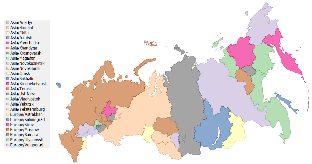
The result matches this map.
The ingredients (zip, sha1) contain a script to build the map from the source, as well as a .prj file for the source map.
First, we take care of a topological problem: we merge the Kizilyurt Gorsovet and the Kizilyurtovskiy Rayon (in the Dagestan Republic); this does not cause a problem since the whole republic is in a single timezone.
Next, we progressivly transfer all the geometries with their corresponding tzid into a new layer and dissolve that layer on tzid.
 To the extent possible under law, Eric Muller has waived all copyright and related or neighboring rights to the efele.net/tz maps (comprising the shapefiles, the web pages describing them and the scripts and data used to build them).
This work is published from the United States of America.
To the extent possible under law, Eric Muller has waived all copyright and related or neighboring rights to the efele.net/tz maps (comprising the shapefiles, the web pages describing them and the scripts and data used to build them).
This work is published from the United States of America.
Note that this does not affect the rights others may have. I am not qualified to determine whether such rights exist.
History: