Last data update: May 28, 2016
Last page update: May 28, 2016
TZ version: 2016d
The tz_world shapefile (zip, sha1) captures the boundaries of the TZ timezones across the world. The geometries are all POLYGONs, and a TZ timezone will sometimes have multiple polygons. There are about 28,000 rows.
The tz_world_mp shapefile (zip, sha1) captures the same boundaries. The geometries are either POLYGONs or MULTIPOLYGONs, and there is a single geometry for each TZ timezone.
There is a companion map for the TZ timezones used in Antarctica stations.
The geometries are primarily derived from the fip10s data (itself derived from the VMAP0 data), augmented with data presented in the pages for the maps of the United States, Canada, Mexico, Russia and China.
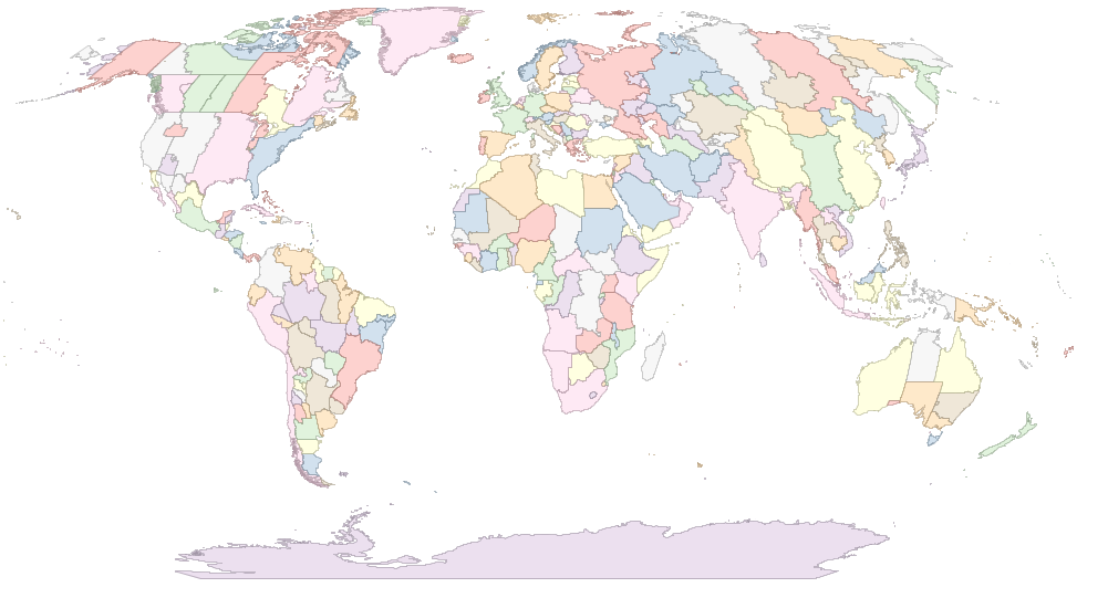
This is a snaphsot of the zones (many of the smaller zones are not visible at this scale):
The tz database says: “A ship within the territorial waters of any nation uses that nation's time. In international waters, time zone boundaries are meridians 15° apart, except that UTC−12 and UTC+12 are each 7.5° wide and are separated by the 180° meridian (not by the International Date Line, which is for land and territorial waters only). A captain can change ship's clocks any time after entering a new time zone; midnight changes are common.”
While the boundaries in international waters are not difficult to construct, the boundaries of territorial waters are a completely different story, and are similar to the boundaries between countries. Unfortunately, VMAP0 does not provide geometries for the territorial waters. As a consequence, the shapefiles presented here do not cover seas and oceans.
The vast majority of the tz timezones are by construction matching a country, so little needs to be said about them: we equate them with the corresponding region in our fips10s data. We also discussed the situation of the United States, Canada, Mexico, Russia and China in other pages. That leaves only a few countries with multiple time zones, and again, most of them are straightforward, with timezone matching administrative divisions of the countries: the correspondance is documented in the script we use to build the shapefile (see below). The rest of this section discusses the remaining cases, where the definition of the extent of a zone is open to interpretation.
This country is covered by two tz timezones, Tashkent and Samarkand. There is not enough information in the tz data to figure out how Uzbekistan is divided between them. We use a separation along first-level administrative divisons that matches WTE.
This country is covered by four tz timezones. There is not enough information in the tz data to figure out how Ukraine is divided between them. We use a separation along first-level administrative divisons that matches WTE.
The extent of the Eucla zone is not clear from the tz data. The only clue is that the timezone ends just east of Caiguna. We arbitrarily make that zone the intersection of a rectangle and Western Australia: Caiguna is a 125.490E, so we use somewhat arbitrarily 125.5E as the west boundary; the north boundary is arbitrarily -31.3S; the south boundary is the ocean; the east boundary is the Western Australia/South Australia border.
The Lindeman zone is said by tz to include the three islands of Hayman, Lindeman, Hamilton, all in Queensland. There are other islands in this area, but we don't include them, for lack of better information.
The Broken_Hill timezone is defined by law as the county of Yancowinna, New South Wales. The geometry was obtained by georeferencing and tracing of this image of the counties of New South Wales
It is difficult to obtain reliable and verifiable information on time zones in Mongolia: see this summary. We use the following setting:
According to this report,
Regardless of what Cuba does, the U.S. Naval Base Guantanamo Bay will always be in the Eastern Time zone and will always observe daylight saving time as this allows the naval base to remain in synch with their headquarters in Florida. This information was confirmed with the assistance of the Public Affairs Officer at the U.S. Naval Base Guantanamo Bay.
Accordingly, we assign it the America/New_York timezone.
The Kwajalein zone is certainly no less than the 11 islands leased by the US on the Kwajalein atoll. It’s also very unlikely to be more than the Kwajalein atoll itself. We use the whole atoll as the extent of the zone.
Most of Spain is easy. The open question concerns the Plazas de soberania. Clearly, Ceuta is in Africa/Ceuta, but the timezone of Melilla, Chafarinas, Peñón de Alhucemas, and Peñón de Vélez de la Gomera is unclear. Our base map does not have areas for the last two, and we use Africa/Ceuta for Melilla and the Chafarinas.
In this map, we consider all of Antarctica to be uninhabited. The companion map Antarctica captures the permanent bases and the TZ timezones they use.
The boundaries between the four zones are somewhat arbitrary.
The ingredients (zip, sha1) contain a script to build the map from the source, as well as a .prj file for the source map.
For the United States, Mexico, Russia and China, we started from the tz maps for those countries and turned them manually into masks; the idea is to retain from them only the boundaries that are not present in our base map. Those mask shapefiles are in the ingredients.
For Canada, we use directly the masks that served to create the Canada map.
For Brazil, we use a mask built from 1) the great circle from Tabatinga to Porto Acre to divide east from west Amazonas, and 2) the Xigu and Javary rivers from the VMAP0 inwatera (inland water area) layer to divide east from west Para.
For the exact details of the tz assignments, see the script in the ingredients.
 To the extent possible under law, Eric Muller has waived all copyright and related or neighboring rights to the efele.net/tz maps (comprising the shapefiles, the web pages describing them and the scripts and data used to build them).
This work is published from the United States of America.
To the extent possible under law, Eric Muller has waived all copyright and related or neighboring rights to the efele.net/tz maps (comprising the shapefiles, the web pages describing them and the scripts and data used to build them).
This work is published from the United States of America.
Note that this does not affect the rights others may have. I am not qualified to determine whether such rights exist.
History: